Lateral markers
When driving a car, there are lanes marked indicating the correct path to drive along. However, with a boat, no such references exist, so it becomes harder to know your position relative to the proximity of dangers such as sandbars and reefs. Poor understanding of the navigation aids will put your boat on the rocks.
- Navigation aids may be in the form of buoys, piles or floating beacons.
- Marks may contain one or more identifiable characteristics such as colour scheme, shape, light colour and more.
- When numbered, odd number marks are starboard and even number marks are port in the direction of buoyage.
- A nautical chart is one of the most fundamental tools available to the mariner. It is a map that depicts the configuration of the shoreline and see floor. It provides information on water depth, locations of dangers, location and characteristics of navigation aids, safe anchorages and other features. The nautical chart is essential for safe navigation. Vessel operators should always refer to these charts. You will need to pre-learn each area of vessel operation prior to commencing your trip.
- Maintain a proper lookout at all times and operate at a safe speed.
Navigation marks and signs establish a system to assist safe navigation. You must be able to identify and be familiar with the different types of markers, and which side you need to travel on, particularly when travelling upstream or downstream in enclosed waters.
AUSTRALIAN LATERAL MARKERS (CHANNEL MARKERS)
Traffic lights and signs guide drivers on the roads. Buoys, beacons and navigation lights do the same on the water. Lateral markers help us safely navigate our waterways.
Red Port Marker
Port markers are red and have a can-shaped top-mark or buoy. When lit, a port hand mark shows a flashing red light.
Green Starboard
Starboard markers are green and have a cone-shaped top-mark or buoy. When lit, a starboard hand mark shows a flashing green light.
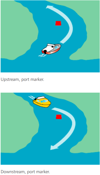
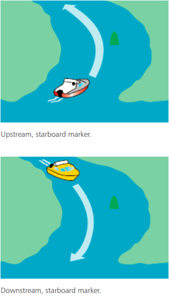
Lateral navigation marks are not often placed in pairs. This means you’ll need to know which side is the safest side to pass on. The safe side of a lateral navigation marker is determined by your direction of travel to, or from, the sea.
NOTE
A simple, yet effective tool to help remember lateral marker sides to learn the phrase: “Upstream, Red Port Left”. This means when going upstream, keep red port on left. Therefore, the green marker is on your right. The opposite applies when going downstream.